An Official Plan update was submitted on October 14, 2025, requesting that City Council approve an update to the pending 2021 Official Plan Background Report, created to replace Sault Ste. Marie’s current in-force Official Plan that dates back to 1996. In other words, our City is currently under the guidance of an Official Plan that was ratified in 1996, which is thirty (30) years old.
The updated 2021 Official Plan, pending approval, was created using pre-pandemic data; however, the Sault is in no way the same as it was; our City has undergone extraordinary changes and faces tumultuous challenges ahead. So the question is: Will the new Official Plan deliver the right growth for our City while also containing costs?
The Official Plan is a far-reaching document that encompasses all aspects of our City’s operations, and it draws on data from 2016-2019. This is the number one problem: the data sets are now too old; too many changes have occurred in our City that allow us to create Official Plan policy and procedures based on outdated data. Population and employment data needs to be re-examined.
Along with outdated data, in my opinion, the updated Official Plan lacks a modern methodology, policies and procedures, GIS Data Mapping, and a new solution for creating growth in the City while controlling costs.
For example, the updated 2021 Official Plan recommends expanding five new Urban Settlement Areas (USAs) and two more under the October 14, 2025 addition, for a total of seven new land parcels added to the Sault’s Urban Settlement Areas (USAs). These additional USAs are all on our City’s perimeter and will increase the City’s physical size and extend its boundary. These Urban Settlement Area additions are most likely for residential housing developments.
Expanding Sault’s USAs for residential development incurs additional costs without understanding how much revenue will be generated from these developments. I question some of these new subdivisions approved by the City Planning Department; for example, the subdivisions at the end of Queen Street East have massive 250-plus frontages, are sparsely occupied, with many empty lots, yet the City has to maintain them.
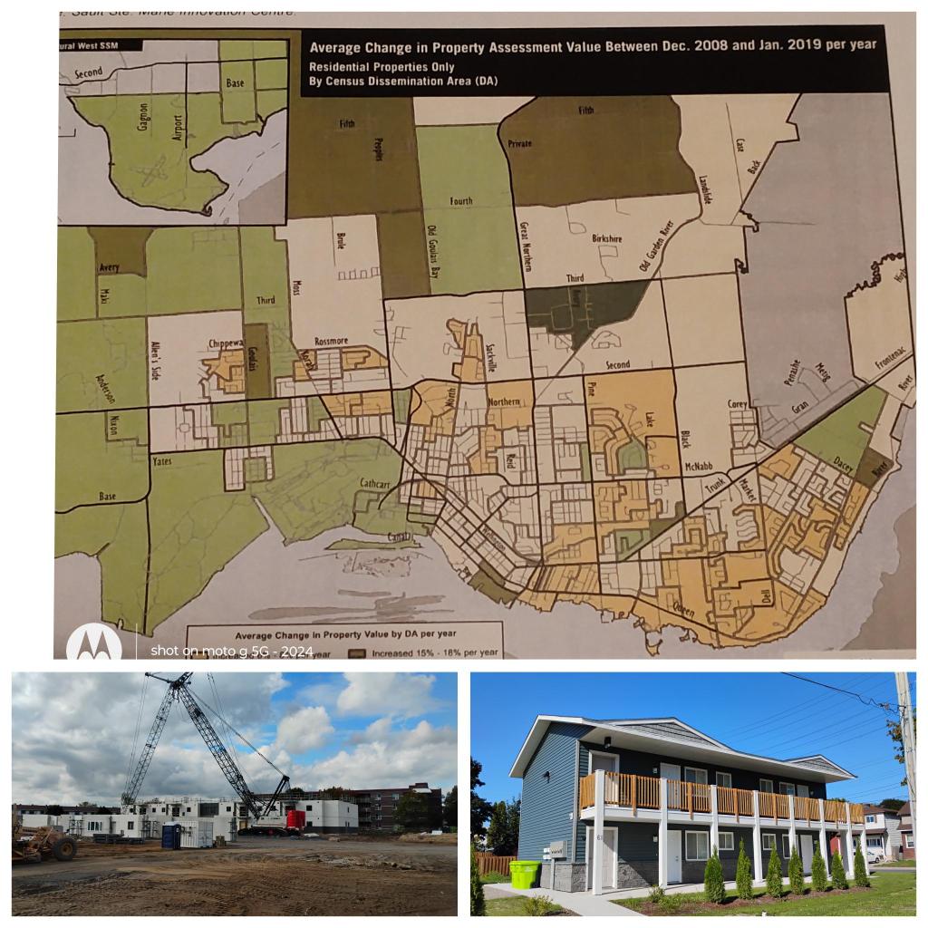
Do these subdivisions cost more to maintain than the tax money they generate? Nobody knows for sure. The best way to understand where a City makes or loses money would be to create GIS (Geographic Information System) Maps that identify the total tax revenue generated in each area of our City. The updated 2021 Official Plan does contain a very basic GIS Map, “Average Change in Property Assessment Value Between Dec. 2008 and Jan. 2019,” that shows the increase in property assessments across different neighbourhoods in the Sault. The inherent problem with this basic GIS Map is that it is not detailed enough to allow us to determine which areas, blocks, or subdivisions are net positive tax generators and which are net negative tax losers to our City’s tax levy.
The City of Sault Ste. Marie invested in GIS technology over thirty years ago, and more accurate GIS Data and GIS Mapping were needed in the new, updated 2021 Official Plan to better understand our City from a financial, tax literacy perspective, using real data and mapping it.
Expanding our City’s USA boundary without understanding the cost-versus-benefit results in a 1996 Official Plan methodology in which McMansion subdivisions are approved with the “hopes” that they are net positive to the City’s tax levy; in most cases, they are not.
The other option would be to change the City’s Official Plan methodology to one adopted by Michigan Cities, called HOAs (Homeowners Associations). A HOA requires a new residential subdivision to be fully built and managed by the private sector; the municipality will NOT provide any services whatsoever. Homeowners in the subdivision pay an HOA fee to cover all the ongoing costs of maintaining the subdivision. The homeowners still have to pay municipal taxes (usually slightly reduced); that doesn’t change. Municipal taxes still must be paid. What’s changed is the methodology for planning city growth: they support new subdivision growth but will not expand their city’s operating footprint or operations budget.
An increase in the size of the Sault’s USAs will require additional maintenance staff, equipment, storage/service garages, administrative costs, and other fees. So again, can the additional taxes generated by this USAs expansion offset the extra costs? Easy answer: GIS Map the data, put it in the new Official Plan, and then we will know for sure.
There is an environmental cost to growing our City’s USAs called greenhouse gas (GHG) emissions, or increased carbon emissions. Sault City Council unanimously committed to reducing our community’s GHG emissions to net zero by 2050. Recent data suggests that City operations have been discharging more GHGs in 2022 than in 2017. The 2021 Official Plan recommendation to expand the City’s USAs for low-density residential housing is bound only to increase GHG emissions in our City, rather than find ways to curtail them.
Expanding Sault’s USAs represents an outdated Official Plan policy of continuing to expand the City rather than finding a way to create greater density using the existing infrastructure. The population density of Sault Ste. Marie has approximately 324.6 people per square kilometre, compared to 4,428 in Toronto, according to 2021 Census data. The best place to build new missing middle housing is in the low-density areas of our City with existing infrastructure.
A recent City Engineering Department report states that there is a backlog of approximately $300 million in infrastructure upgrades to the “old neighbourhoods” of our City. An adequately funded Urban Blight Removal Program is necessary to coincide with infrastructure upgrades, ensuring that new missing middle housing is built into these old neighbourhoods to get the best value for the dollar spent on these upgrades. Unfortunately, the updated 2021 Official Plan does not include a policy, a strategic plan, or a methodology for addressing urban blight removal in the Sault.
The updated 2021 Official Plan calls for 4,000 new housing units by 2039, of which 65% (2,600) are single-family detached homes. Another interesting statistic in the Sault’s Housing Needs Assessment document indicates that 11,000 homes in the City of Sault Ste. Marie have one (1) occupant, mostly senior. Assuming that seniors occupy 60% of these single-occupant, single-family homes, which translates into 7,150 available housing units, means there is no need to increase the Sault’s USAs. In reality, the greatest housing needs in our City fall under two categories: affordable senior housing and financially assisted social housing, not McMansions. We need to free up the readily available single-family homes occupied by one person.
The updated 2021 Official Plan was drafted prior to the COVID pandemic and the spiralling, out-of-control costs of new home construction. A newly constructed single-family home is no longer affordable to the vast majority of families in the Sault. That is why so few are built, and in the future, that housing category will be relegated to custom-built McMansions with massive lots and garages.
The City of Sault Ste. Marie does not need to expand its Urban Service Area as recommended in the updated 2021 Official Plan—the City of Sault Ste. Marie needs a new Official Plan that includes an Urban Blight Removal Plan to allow the construction of affordable housing in existing “old neighbourhoods,” creating growth without adding costs.
Mark Menean, http://www.saultblog.com
Thank you: October 14, 2025 Official Plan update.
Updated 2021 Sault Ste. Marie Official Plan Background Report.
Sault Ste. Marie Housing Needs Assessment.
Statistic Canada 2021 Data.

Leave a comment